The railroad shaped the Niwot we know.
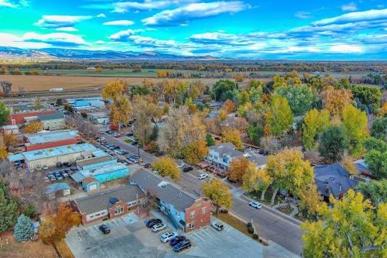
Niwot exists because a rail line was built through the Left Hand valley in the 1870s. The town plat was recorded in 1875, and the street grid still follows the tracks rather than the county roads that came later. The brick block on Second Avenue is what remains of that decision.
It has never been an incorporated municipality. There is no mayor and no town hall, which is part of why the place feels the way it does: what happens here is organized by the people who live here, through the business association, the arts groups and the neighbors who show up.
Niwot is named for Chief Niwot.
Chief Niwot was a leader of the Southern Arapaho, whose people lived in and travelled through this part of the Front Range long before the town site was surveyed. His name, rendered in English as “left hand,” is carried by the creek that crosses the valley, by the water district, and by the community itself.
In November 1864, Colorado volunteer cavalry attacked an encampment of Cheyenne and Arapaho people at Sand Creek, killing mostly women, children and elders. Chief Niwot was among those wounded there and died shortly afterward. The Sand Creek Massacre is recognized today as a massacre by the United States government, and it is inseparable from the history of the name this community uses.
That history is not a decorative origin story, and a community guide is not its proper author. The account above is deliberately brief and points to the nations and institutions that hold it.
How the community got here
Each entry names what it rests on. Where a date is contested or unverified, it says so rather than carrying an approximation.
-
Before 1875Arapaho and Cheyenne nations; NPS; History Colorado
Arapaho presence, and Chief Niwot
The Southern Arapaho and Cheyenne lived in and moved through the Left Hand valley and the plains below the foothills. Chief Niwot, for whom the community is named, led a band of Southern Arapaho in this area. He was wounded at the Sand Creek Massacre in November 1864 and died soon after. This entry is a pointer, not a summary: read the nations’ own accounts and the National Park Service record.
-
1870sRecorded town plat; county records
The railroad, and the 1875 town plat
A rail line built through the valley set the location of the town site. The plat was recorded in 1875, laid out along the tracks. That survey is why the street grid runs as it does, at an angle to the later county road pattern.
-
Late 1800s onwardStanding buildings; county records
The commercial district takes shape
Brick and false-front commercial buildings went up along Second Avenue to serve the surrounding farms and the trains that carried their crops. The Niwot Tribune building is among the survivors of that period and still anchors the block.
-
Twentieth centuryBoulder County records
Growth, and a preserved main street
Residential development spread around the original plat while the historic commercial buildings on Second Avenue were retained rather than replaced. Cottonwood Square later added a second cluster of shops and everyday services. Governance stayed with Boulder County and the special districts throughout.
-
Today2020 census, Niwot CDP
About four thousand people, still unincorporated
The census designated place recorded a population of 4,306 in 2020. Niwot remains unincorporated, with county and district services, and in November 2026 voters inside a proposed boundary decide whether it should become a municipality.
A community of about four thousand people.
Two commercial clusters, a historic district, and farmland that starts where the sidewalks stop. Services come from Boulder County and a set of special districts rather than a town government, and in November 2026 residents inside a proposed boundary vote on whether that should change.
Editorial standards
Population is the 2020 census figure for the Niwot census designated place. Historical dates come from the recorded town plat and county records. Indigenous history follows the published material of the Arapaho and Cheyenne nations, the National Park Service and History Colorado rather than this guide’s own summary.
If something here is wrong, it is corrected with the date and a note describing what changed. A claim that cannot be supported is removed rather than softened.